


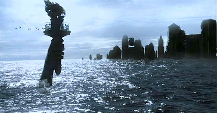
Rising sea levels and disappearing ice caps have been a staple of science fiction futures ever since the first alarm bells were sounded that an ice-free earth was a possibility, no matter what culprit is left holding the smoking gun. (Though at this point, the science is long since in: climate change is happening, and the main cause is human activity.) We’ve seen these watery worlds depicted many times, particularly in film, with varying degrees of success—Waterworld springs immediately to mind. There’s such massive visual appeal to the image of once-great cities like New York inundated by the rising tides; skyscrapers become a new sort of submarine canyon for the divers of the future to explore.
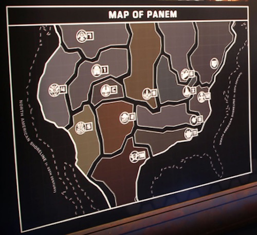
And more recently, we’ve seen the US truncated from both directions by the Atlantic and Pacific in The Hunger Games. We don’t know a whole lot about what changed the shape of North America to give us Panem, other than the fact that the sea level rose to an unknown degree, and there was some sort of cataclysmic war.
I am here, I confess, to rain on that parade. If all of the ice on the entire planet melted, sea level would rise about 65-70m, depending on who you ask, and there’s probably some wiggle room in there for the thermal expansion of water on a much warmer Earth. But even at its fullest extent, the rising tide isn’t going to swallow skyscrapers whole. New York City has a multitude of buildings over 300 (~91m) feet tall, which would stick out of the ocean like steel and glass islands. Duluth, Minnesota could technically get buried under the waves—except that it’s on Lake Superior, not an ocean coastline, and the Great Lakes will mostly be just fine.
Sorry.
But we can have a new set of visuals, of skyscrapers poking up between wind-scudded ocean waves, the glittering remnants of a submerged civilization. People could be building new homes over the ocean, knocking out the windows above floor thirty. Except for the part where the water-flooded buildings, having not been designed to be submerged, collapse.
Double sorry.
It is a fact of rising sea levels that coastlines will change, and that people will be driven inland ahead of the inundation. Most humans live in proximity to a body of water, and as the sea level—what we refer to in sedimentology as “base level”—goes up, rivers will flood back inland as well, becoming wider. But looking at the fictional map of Panem (this one taken from The Hunger Games Experience exhibition, so I think it’s about as official as we’re going to find) it’s worth noting that not all coastlines are equal, and some will be affected much more drastically than others. It all comes down to plate tectonics.
In plate tectonics, there are two types of continental boundaries: active and passive. Active boundaries are where massive tectonic plates, normally a continental plate versus an oceanic plate, are actively colliding. This is the situation we see around the Pacific Ring of Fire, where the Pacific Ocean plate collides with all of the surrounding continental plates, continuously. And since ocean crust is denser than continental crust, the oceanic crust subducts underneath the continent. This is what causes the earthquakes and volcanoes that plague the zone—and also what causes those active margins to have a lot of mountains.
I used to have a bumper sticker on my car that said, “Subduction causes orogeny. Think of the children.” Not only is it hilarious if you like stupid science puns, it’s also true. Subduction—oceanic crust grinding down under the continental crust—provides the compressive pressure that causes orogeny—mountain building. Active margins, which come with subduction zones, tend to experience a lot of compression and folding of crust, which equals mountain building. Which equals elevation. Which equals not getting drowned as quickly when the sea level starts to go up. This is the case with the west coast of North America and South America.
(Fun fact: The mountain ranges on the west half of North America get younger as you head east. The hypothesis is that a piece of subducting oceanic crust was unusually buoyant and kept grinding along under North America until it got about halfway along before finally succumbing and dropping off.)
On the other hand, you have passive margins, which is basically the case for the eastern coastlines of North America. It’s nice and non-volcanic over there, but the tradeoff is that there hasn’t been mountain building in quite some time. And in that quite some time, water’s had its chance to bring the land closer and closer to base level via erosion, making for a gentle, close to sea level slope that heads out into the Atlantic. And when you have a long, low slope, just a little sea level change means the ocean heads far inland.
This brings us back to the puzzling map of Panem. The east side of the former United States makes plenty of sense—that’s pretty much in line with what I’d expect from a drowned world, assuming that rivers haven’t been included on the map. But what is up with the west coast? If the war was so cataclysmic that it bombed the elevation right out of California, I’m surprised Katniss is human and not a large, mutant cockroach. For comparison, here’s a map from CalculatedEarth.com with a projected sea level rise of 70m—the maximum we could really expect.
This future we’re imagining is not alien and unknowable. It’s even likely, given our current course as a species. There are a lot of useful tools for imagining the landscape of a future, ice-free Earth, with the relative grimness, or the human spirit’s capacity for bouncing back, determined by imagination. Here are a few of my favorites:
- At Geology.com you can go from present to +60m of sea level rise overlaid on regular road maps.
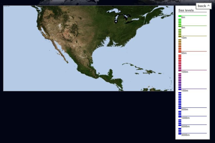
- At CalculatedEarth.com, there’s a fun tool that lets you play with sea level rise up to an absolutely impossible 3000m. (You’d better have a good explanation of where all that water came from, ahem Waterworld.)
- And National Geographic has a series of beautiful paintings showing the changing coastlines of flooded continents, with the old coasts still outlines.
There’s something weirdly fun about drowning the entire world with the twiddle of a slider on a web app, like you’re a merciless god in pajama pants—at least until you’re reminded that you’re forecasting the future of our world and species. Sometimes speculative art meets life in cognitively discomforting ways.
There are plenty of other questions surrounding sea level rise that we don’t know the answer to. What is the inundation going to do to local climates? What plants and animals and entire ecosystems will survive and what will their new ranges be? What about those moving shorelines? But we know with a reasonable degree of accuracy where those shorelines will end up being: the Earth and its elevations are very well-mapped, and sea level rise is a heartlessly mathematical process.
I feel I should apologize for this being much more of a downer than the endless squee about desert planets in my previous post, but I did my thesis research on climate change, and this is the sort of thing that keeps me up at night. I’m putting out the call and leaving it to you to imagine stories of survival and hope as the slider on our sea level reality creeps higher.
Alex Acks is a writer, geologist, Twitter fiend, and dapper AF. Their sweary biker space witch debut novel, Hunger Makes the Wolf, is out now from Angry Robot Books.